Tour du Queyras trail (GR58) - 9 days/8 nights
Ready for the Tour du Queyras adventure?
Discover one of the most famous trails in the French Alps. This 130km itinerary goes all the way round the Regional Nature Park. It offers the bonus of retracing this authentic region’s history, cultural heritage and natural wealth!
The GR58 will reveal the secrets of this highland and all its resources on an entertaining and challenging hike.
The GR58 will reveal the secrets of this highland and all its resources on an entertaining and challenging hike.
Stages of the route
stage 1From Ceillac to Saint Véran
see the map
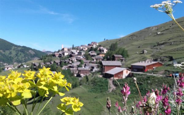
Your hike begins at Ceillac, at the gateway to the Queyras valley. First, the path winds across the shady Cristillan valley before turning towards the north. This is when you really start your ascent to Estronques pass (2,651m) and get to contemplate the splendour of the Ecrins glaciers. At the top, a superb panoramic view over the Ceillac valley unfolds amid the arid landscape that stretches across the Tête de Jacquette ridge. On the way back down you’ll be able to admire the Molines hamlets and the Aigues valley, as well as an emblematic forest of the Queyras populated with arolla pine and larch. The first stage of your itinerary ends at Saint Véran, often cited as being the highest village in Europe. Indeed, the centre of this typical mountain village stands at 2,042 metres above sea level.
For further information
Elevation gain/lossD+ 1000 m/D- 800 m
Time6h30
stage 2From Saint Véran to Agnel Refuge
see the map
During this second stage you'll cross the Chamoussière pass, the highest point of the itinerary. In fact, its elevation of 2,884 metres makes it the highest pass to be included in a long-distance hiking trail. From Saint Véran, the path starts on the mountainsides below the Cascavelier and Marcel peaks, in the shade of a forest on the banks of the Aigue Blanche. Approaching the Clausis chapel, the landscape changes radically and your climb up to the Chamoussière pass ends in the beautiful Alpine pasture of the Cirque de la Blanche. From the col, you can enjoy the treat of a short return trip to the Caramantran peak, the easiest Queyras summit exceeding 3,000 metres. Next, your descent to the Agnel refuge (2,580m) takes you down an enormous scree slope!
For further information
Elevation gain/lossD+ 700 m/D- 900 m
Time5h
stage 3From Agnel Refuge to L’Echalp (or La Monta)
see the map
The first part of this third stage takes you to the Vieux pass (2,806m) where ibex and chamois can be seen in this protected sensitive area. A there-and-back detour via the Pain de Sucre (3,208m) offers a stunning view over the Ristolas-Mont Viso nature reserve and the fossil glaciers. The long descent from Vieux pass to the Bouchouse valley gives you a chance to admire Lakes Foréant and Egorgeou, and to enjoy the wonderful spectacle of the Taillante ridge and other surrounding peaks reflected in their clear waters. The marshy lakeside is home to some exceptional fauna and flora. The path then leads into the valley under the shade of the larch trees. Passing close to the Médille chalet, you’ve almost arrived at L’Echalp, a small hamlet located on the banks of the Guil. (You can also spend the night at La Monta, just 1km from L’Echalp.)
For further information
Time5h
stage 4From L’Echalp (or La Monta) to Abriès
see the map
This fourth stage promises to be spectacular! You'll climb the slopes of the Guil valley to the foot of Tête du Pelvas. From there, you'll leave the larch forest behind you for a 2km walk on the ridges of Peyra Plata and Gilly, with their superb scenery and panoramic views to take your breath away! Your return to Abriès from the Gilly pass is down through the valley’s decor of pastureland and forest. (Possible variant to Le Roux d’Abriès)
For further information
Time5h30
stage 5From Abriès to Fonts de Cervières
see the map
This fifth stage starts on a beautiful balcony path above the Guil valley. You’ll then cross Le Malrif, one of the abandoned hamlets of Abriès. The panorama gradually unfurls as you approach the slopes of Pic du Malrif. At this point you cannot miss the majestic Lake Grand Laus in its exceptional mountain landscape. You can enjoy a short walk to the Malrif lakes and back before climbing up to the col of the same name. From there, a quick detour up to the Malrif peak offers a view over the entire Queyras valley as well as the splendid Ecrins mountains. No doubt about it, the Malrif cirque will be among your best memories of this hike. Once over the col, the path continues across an amazing lunar landscape before your descent begins to the Fonts de Cervières valley to conclude this stage of your hike.
For further information
Elevation gain/lossD+ 1200 m/D- 900 m
Time6h30
stage 6From Fonts de Cervières to Arvieux
see the map
To reach Arvieux from Les Fonts de Cervières, first head south towards the Péas pass (2,629m)! So you’re now at the foot of Grand Rochebrune, the second highest peak in the Queyras, at 3,321 metres. The descent through the pastures to Souliers hamlet is superb! Next, you’ll climb to the Tronchet pass (2,347 m). Along the way you can enjoy the cold waters of a few handy fountains. You can stay for the night at Brunissard or La Chalp d’Arvieux.
For further information
stage 7From Arvieux to Furfande
see the map
This seventh stage starts along the banks of the Champ-la-Maison torrent. The point where it meets the Plan du Vallon torrent marks the start of your climb to the Furfande pass, which reaches 2,500 metres. The summit’s approach is across grassland and offers much clearer views. Your descent is via these same mountain pastures dotted with over a hundred typical Queyras chalets. You'll end your day at a refuge where the night promises to replenish your energy.
For further information
Time5h
stage 8From Furfande to Bramousse
see the map
The eighth and penultimate stage of your itinerary takes you to the small hamlet of Bramousse via the Lauze pass (2,076m). You’ll return through the trees, via the beautiful hamlet of Les Escoyères (2 permanent residents) which you'll find in the middle of the larch forest. Your descent continues to the bottom of the Guil valley , then crosses to the opposite slope and the hamlet of Bramousse with its Sainte-Marguerite and Notre-Dame-du-Pontet chapels.
For further information
Time4h30
stage 9From Bramousse to Ceillac
see the map
This final stage begins with a path that alternates between forest and pastureland before reaching the Bramousse pass (2,251m). From there, you have two options: either descend directly to Ceillac to end your trek across Queyras, or take a little detour via the old outlook post on the Chambrettes ridge and the Fromage pass (2,301m).
For further information
Time4h30
Book your accommodation
for this hike
stage 1
From Ceillac to Saint Véran
Chalet l'Estoilies
Gîte Les Gabelous
La Baïta du Loup
Gite auberge Costebelle
stage 2
From Saint Véran to Agnel Refuge
Refuge Agnel
stage 3
From Agnel Refuge to L’Echalp (or La Monta)
7 Degrés EST
Gite de la Monta
stage 4
From L’Echalp (or La Monta) to Abriès
Ancolie bleue
Chalet le Cassu
Abries-Le-Villard
Edelweiss
stage 5
From Abriès to Fonts de Cervières
Refuge des Fonts
stage 6
From Fonts de Cervières to Arvieux
la Fruitière
La Teppio
Les Bons Enfants
Le Chalet Viso
stage 7
From Arvieux to Furfande
Refuge de Furfande
stage 8
From Furfande to Bramousse
Le Riou Vert
stage 9
From Bramousse to Ceillac
Refuge de la Cime
Gîte Les Baladins
Departure arrival1630 m
Arrival altitude1630 m
DifficultyIntermediate
Season


Creation: Alliance-Réseaux